 "TheRealBicycleBuck" (therealbicyclebuck)
07/15/2020 at 11:59 • Filed to: None
 2
2
 15
15|
"TheRealBicycleBuck" (therealbicyclebuck)
07/15/2020 at 11:59 • Filed to: None | 2
| 15 |

I’m learning how we are training our future overlords how to recognize plants. Frankly, it’s amazing. One of the new AI tools allows field personnel to take a picture of a plant and the AI on the back end will automatically identify it for you. Now there’s no need for a botanist, arborist, or forester to do your tree survey. You just need a guy with a phone and the right app.
While you can’t watch the live event, they have published the slides so you can get a view of what they’re doing. It’s amazing.
!!!error: Indecipherable SUB-paragraph formatting!!!
 For Sweden
> TheRealBicycleBuck
For Sweden
> TheRealBicycleBuck
07/15/2020 at 12:10 |
|
pfft who need maps
|
TheRealBicycleBuck
> For Sweden
07/15/2020 at 12:14 |
|
YOU! YOU NEED MAPS!!!!
 Highlander-Datsuns are Forever
> TheRealBicycleBuck
Highlander-Datsuns are Forever
> TheRealBicycleBuck
07/15/2020 at 12:19 |
|
Nope. I leave that to the GIS experts.
 davesaddiction @ opposite-lock.com
> TheRealBicycleBuck
davesaddiction @ opposite-lock.com
> TheRealBicycleBuck
07/15/2020 at 12:26 |
|
I signed up, but haven’t (yet). Hopefully everything’s viewable later. Thanks for the link - it’s truly incredible what’s possible now.
|
TheRealBicycleBuck
> davesaddiction @ opposite-lock.com
07/15/2020 at 12:48 |
|
It looks like a lot of the workshop and user sessions will be available, but they are selling the proceedings on a USB drive, so long-term availability may depend on your budget.
 ITA97, now with more Jag @ opposite-lock.com
> TheRealBicycleBuck
ITA97, now with more Jag @ opposite-lock.com
> TheRealBicycleBuck
07/15/2020 at 13:27 |
|
I’m not, but our GIS/M apper person certainly is.
 BaconSandwich is tasty.
> TheRealBicycleBuck
BaconSandwich is tasty.
> TheRealBicycleBuck
07/15/2020 at 14:03 |
|
I suspect we work in a very similar field...
I don’t like mentioning who I work for. Sometimes I feel like I work for the evil empire. :( I don’t necessarily agree with some things that our company does, but it pays the bills and allows me to live close to family, so it’s hard to complain.
|
davesaddiction @ opposite-lock.com
> TheRealBicycleBuck
07/15/2020 at 14:13 |
|
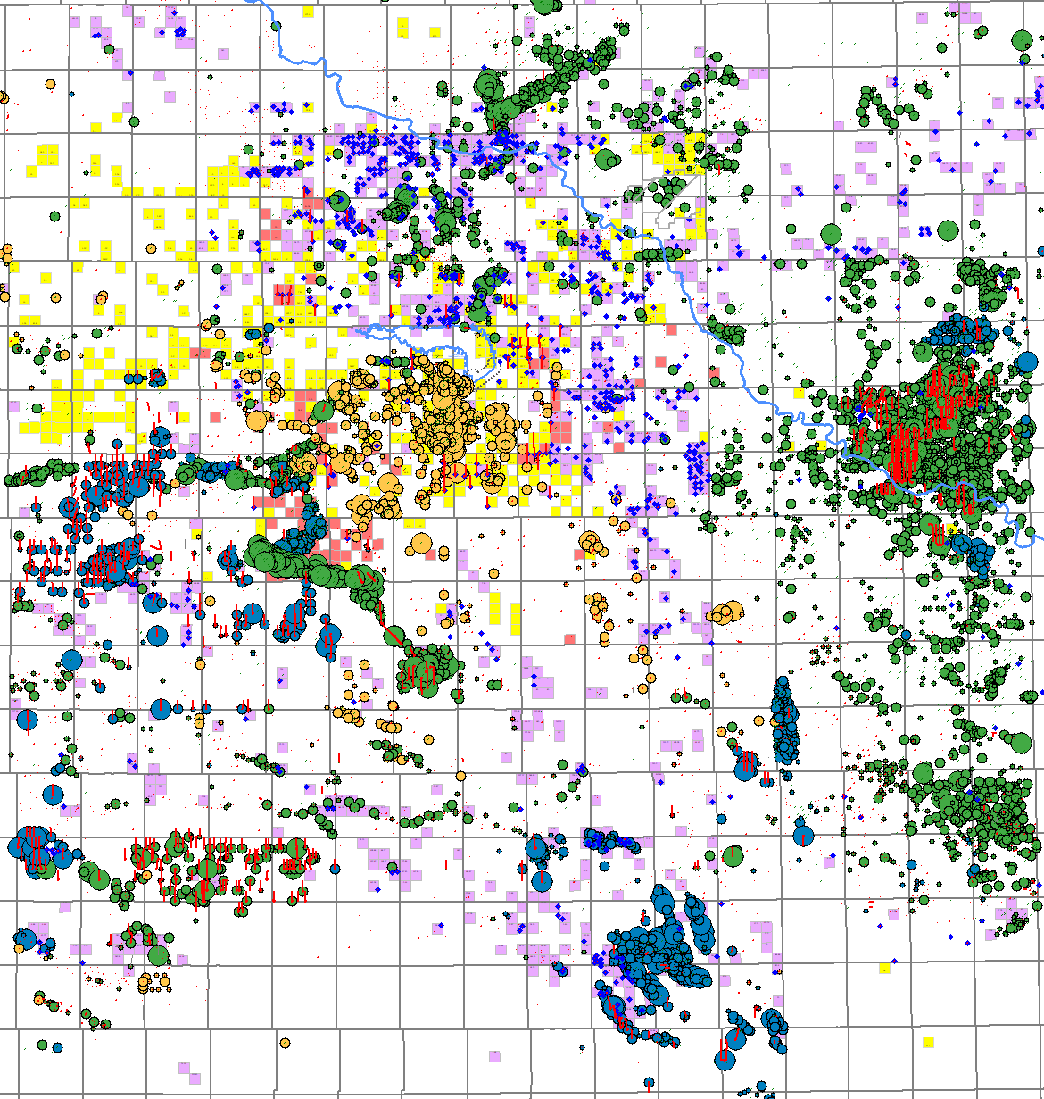
Here’s an interesting map I made recently that I thought you might appreciate (not in ArcMap, but in Petra, our geo interp software):
Bubbles are oil IP (initial production test), colored by age of the producing formation (3 select periods), over our acreage and two potential acquisition targets (with some of their wells highlighted). Horizontal wells shown by red lines, counties and township labels removed as to not give anything away. =)
|
TheRealBicycleBuck
> davesaddiction @ opposite-lock.com
07/15/2020 at 14:39 |
|
That’s pretty nifty! I think we talked before about techniques for estimating subsurface formations from well data. I had an opportunity to exercise that skill determining subsurface soils structures from boring data in preparation for a levee expansion. Fun stuff.
|
TheRealBicycleBuck
> BaconSandwich is tasty.
07/15/2020 at 14:44 |
|
I try to keep my employer info quiet, but I do mostly disaster recovery work these days. That encompasses a lot of different applications of GIS from field data collection to final reporting for FEMA and FHWA disaster recovery applications. I also have a smattering of environmental work, road work, and infrastructure work in there. There’s also planning and policy work. I’m everywhere! While I’m not surrounded by people who do my kind of work, being a skilled resource in an Architecture and Engineering firm gives me a wide variety of work which I really enjoy (usually).
|
davesaddiction @ opposite-lock.com
> TheRealBicycleBuck
07/15/2020 at 14:58 |
|
Boring data...
LOL
Very cool. And very important to get it right!
|
BaconSandwich is tasty.
> TheRealBicycleBuck
07/15/2020 at 15:01 |
|
Ah, so we may be a bit more different. I’m strictly in agriculture. I don’t deal specifically with the satellite imagery, but the product I work on is more or less built around it.
|
TheRealBicycleBuck
> BaconSandwich is tasty.
07/15/2020 at 15:25 |
|
Precision farming or more along the lines of the national ag insurance program?
|
BaconSandwich is tasty.
> TheRealBicycleBuck
07/15/2020 at 16:35 |
|
You got it - p recision agriculture.
|
TheRealBicycleBuck
> BaconSandwich is tasty.
07/15/2020 at 16:43 |
|
Precision ag is one of my favorite applications of technology and it was one of my favorite things to teach back when I was teaching. Getting kids to understand what hyperspectral imagery is and what can be done with it, especially once it’s properly orthorectified. Precision ag gave me the opportunity to talk about the electromagnetic spectrum, remotely capturing data, orthorectification, image analysis, ground-truthing data with soil samples, GPS, and using the information to not only inform the client, but also control the application of supplements. It’s an AMAZING application of technology.